

Top 5 Navigation and Safety Essentials for US Camping and Hiking in 2026
Published on Tuesday, June 2, 2026
The Navigation and Safety category within the camping and hiking sector is the ultimate lifeline for outdoor enthusiasts exploring the vast landscapes of the United States. From advanced GPS communicators and rugged compasses to emergency beacons and comprehensive first aid kits, this gear ensures that adventurers can confidently tackle everything from local state parks to remote backcountry trails. In 2026, US consumers are prioritizing a blend of reliable analog tools and cutting-edge satellite technology. The appeal lies in the peace of mind these products provide, allowing hikers to push their boundaries while staying connected to emergency services and loved ones. As extreme weather and off-grid exploration become more common, investing in top-tier navigation and safety equipment is no longer just an option, but a fundamental requirement for responsible outdoor recreation.
Top Picks Summary
The Silva Ranger 2.0 is a rugged, user-friendly baseplate clinometer compass with a large map-friendly base, practical clinometer markings, and solid sighting capabilities tailored to outdoor navigation and route-finding. It represents a value-oriented middle ground — more feature-dense for field navigation than the budget Brunton TruArc 15, but without the specialized precision and higher price of the Suunto PM-5/360, making it a strong choice for hikers and expedition leaders who need dependable clinometer functions without professional surveyor pricing.
Show More Compasses For Camping And Hiking
AllTrails+ Offline Maps
AllTrails+ offers an easy-to-use offline topographic map experience backed by one of the largest trail databases and extensive user reviews, making offline topo downloads simple and immediately useful for day hikers and casual outdoors enthusiasts. It is financially attractive as a single subscription that unlocks offline maps across many trails, though its topo detail and advanced export/geospatial features are less technical than Gaia or Avenza for professional mapping needs.
Show More Topographic Maps And Plotting Tools For Camping And Hiking
The Garmin inReach Mini 2 earns its spot as the best compact satellite communicator for camping and hiking thanks to true two-way Iridium messaging, an SOS function, and a very small, lightweight footprint that won’t weigh down a pack. It’s a more affordable and portable alternative to Garmin’s GPSMAP 67i, while offering standalone global coverage unlike phone-dependent options such as the ZOLEO; financially it sits in the mid-tier for device cost and subscription outlay, giving strong capability for its price and weight.
Show More Handheld GPS Units For Camping And Hiking
The Apple Watch Ultra 2 is the best choice for hikers who want top-notch smartwatch features combined with strong GPS and altimeter performance, plus integrated emergency services and a polished user experience for iPhone owners. It cannot match the battery endurance of the Enduro 3 or some Coros/Garmin units, but its technical advantage is seamless ecosystem integration and premium connectivity, which can be financially efficient for users already invested in Apple devices.
Show More Satellite Communicators For Camping And Hiking
Blue Jeans Cable Belden 1694A BNC to BNC Video Cable
Blue Jeans Cable's Belden 1694A assemblies target pro video users seeking very low-loss, well-terminated 75-ohm BNC runs and are praised for build quality and clean connectors. For Low-Loss External Antenna Extension Cables with BNC Connectors they are a top video-market leader but, like other 1694A-based products, represent a trade-off for antenna use because the 75-ohm impedance and video-focused manufacture do not match the optimal 50-ohm RF characteristics offered by LMR-240-based assemblies.
Show More Personal Locator Beacons For Camping And Hiking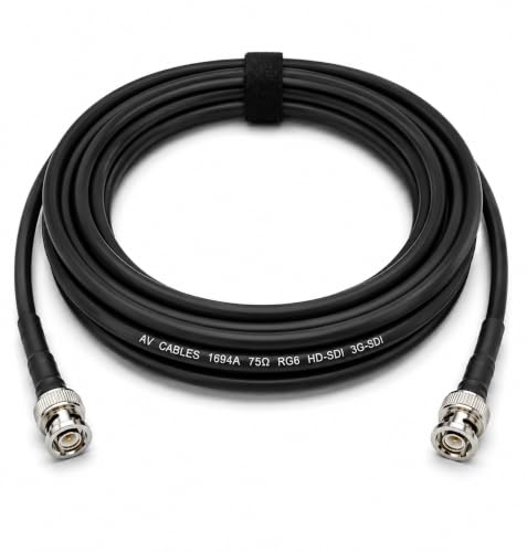
How to Choose the Right Navigation and Safety Gear
The difference between a life-saving tool and a useless weight often comes down to battery reliability and satellite network coverage. When evaluating these devices, prioritize dual-network redundancy and ruggedized weatherproofing over flashy touchscreen displays that drain power quickly.
Check the satellite network: Devices utilizing the Iridium satellite network offer true global coverage, which is critical if you are hiking in deep canyons or dense forests where other networks fail.
Ignore battery life claims based on standby mode; instead, look for the active tracking battery life, which should ideally exceed 100 hours for multi-day backcountry trips.
For analog compasses, insist on adjustable declination and a clinometer, as fixed-declination models are practically useless for precise map work in varying US regions.
Identify your use case: Day hikers on marked trails can rely on smartphone GPS apps with downloaded offline maps and a basic power bank, while multi-day backpackers absolutely need a dedicated two-way satellite messenger.
When buying first aid kits, avoid high piece counts inflated by cheap bandages; look for kits that include trauma essentials like a tourniquet, hemostatic gauze, and a rigid splint.
Frequently Asked Questions
Which navigation tool is best for ultralight hikers needing emergency contact?
The Garmin inReach Mini 2 is the ideal choice for ultralight hikers because it provides two-way Iridium satellite messaging and an SOS function in a compact, lightweight design that fits easily in your pack.
Does the Silva Ranger 2.0 Compass include a built-in clinometer?
Yes, the Silva Ranger 2.0 Compass features an integrated clinometer and inclinometer, allowing you to perform slope and angle checks directly on the trail.
How much does the AllTrails+ Offline Maps subscription cost for hikers?
The AllTrails+ Offline Maps service is currently available for $0.00 USDproviding users with access to a large American trail database, downloadable topographic maps, and turn-by-turn navigation at no cost.
Is the Garmin inReach Mini 2 suitable for multi-day camping trips?
The Garmin inReach Mini 2 is well-suited for multi-day trips as it offers long battery life with customizable tracking intervals to ensure you stay connected throughout your journey.
Conclusion
Whether you are planning a weekend camping trip in the Appalachians or a month-long expedition through the Rockies, having the right navigation and safety gear is essential for a successful US adventure. We hope this guide has helped you identify the perfect equipment to keep you secure and on track. If you need to refine your options or explore additional outdoor essentials, feel free to use the search feature to find exactly what you are looking for.